
|
Continental scale
|
|
Continental
scale
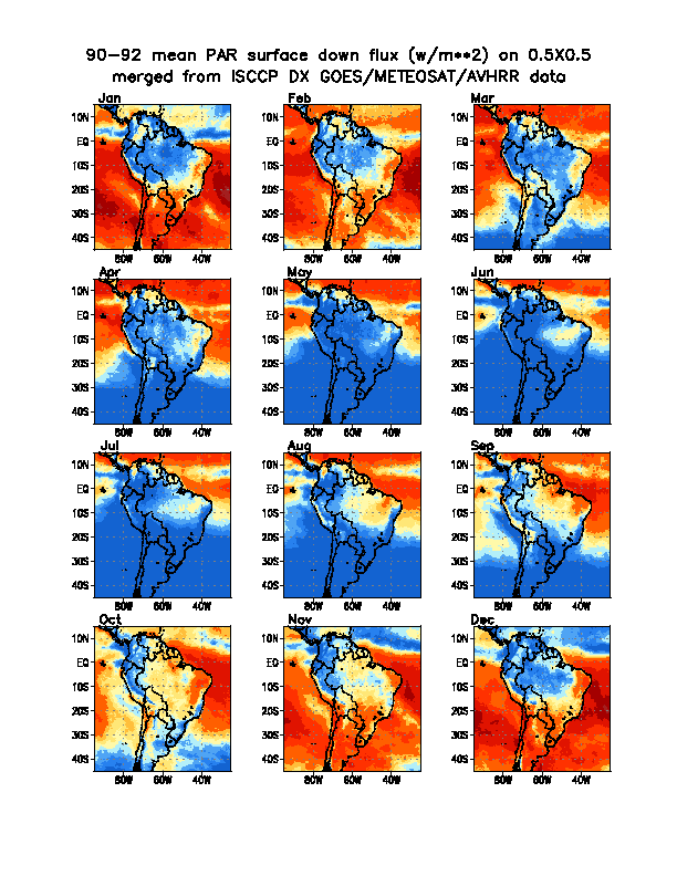
Three
years (1990-1992) of high-resolution radiative fluxes have been processed, based
on the ISSCCP DX satellite observations, over
a domain bounded by (20 S, 7 N and 80 W, 50 W). A three year average of monthly mean values of surface
downward PAR (W/m*2), for South America, is shown in Figure
3. Since the Amazon region is covered both by GOES and METEOSAT
satellites, the satellite observations are merged, using EOF analysis. The data are available at 3 hourly intervals as instantaneous, hourly averaged, daily and monthly means
and distributed via the Global Land Cover Facility (GLCF), Earth Science
Information Partnership (ESIP) Federation, at the University of Maryland, at:
http://glcf.umiacs.umd.edu/data/serf
The monthly mean values of surface shortwave downward and upward flux, NIR surface downward and upward flux,
and PAR surface downward and upward flux,
are provided at this website.
These data could be used by the modeling community to synthesize regional hydrological
models, and to study teleconnections. We plan to obtain a five year record of data at this resolution.
(Figure from Roni Avissar, Duke University, unpublished) |
Maintained by Chuan Li cli@atmos.umd.edu
|
|